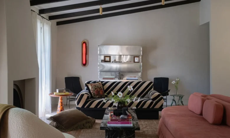
The living room in actor Lucy Hale’s Los Angeles residence serves as a masterclass in controlled eclecticism, anchored by a vaulted ceiling defined by dramatic, dark-wood exposed beams. At the heart of the space, a marble coffee table provides a minimalist foundation for a curated collection of vibrant hardcovers and a wilting, organic arrangement of white cosmos. The seating arrangement is a study in juxtaposition: a soft, dusty-rose velvet sofa sits in conversation with a striking black-and-white striped piece designed by the renowned interior visionary Kelly Wearstler. The visual tension is broken by a fringed, floral-patterned Gucci throw pillow, an accessory that, by traditional design metrics, should clash with the graphic upholstery but instead creates a sophisticated, cohesive narrative.
This residence, developed in partnership with designers Ashley Drost and Marie Trohman of the firm Proem, represents a significant departure from conventional Hollywood interior trends. By leaning into what Drost describes as Hale’s "fun, instinctive, and witchy" sensibilities, the design team has cultivated an environment that favors personality over mass-market uniformity.
Chronology and Collaborative Design Process
The collaboration between Hale and the Proem team began with a foundational desire to move away from the "all-white" minimalism that dominated Southern California residential design throughout the 2010s. The design process was iterative, spanning several months of sourcing and procurement to ensure that the home reflected the actor’s specific, evolving taste.

During the move-in phase, the design team focused on "soft" architecture—the use of textiles, lighting, and placement to define the mood of individual rooms. The now-famous Gucci pillow was not part of the original design schematic; its placement on the Kelly Wearstler sofa was described by Drost as a serendipitous accident during the installation process. The designers opted to keep the pillow in place, recognizing that the friction between the floral motif and the graphic stripe mirrored the "irreverent" energy Hale sought to inject into the property.
As the project progressed, the team integrated more unconventional elements—such as a two-foot-tall sheep statue and a vintage Elvis-themed lamp—to serve as focal points. These items were handpicked by Hale, shifting the home from a standard designer-led portfolio piece to a highly personal sanctuary.
Analysis of Textile Selection and Interior Dynamics
The role of the throw pillow in contemporary interior design has evolved from a purely functional backrest to a primary vehicle for visual expression. In the context of Hale’s home, the pillows act as the connective tissue between disparate styles.
The integration of these pieces follows a specific design theory: the use of "unexpected pairings" to stimulate visual interest. By utilizing bold prints, such as the Scalamandrè Panthera leopard-print lumbar pillows in the entertainment room, the designers managed to ground the space’s lighter, watercolor-based color palette. Data from interior design market studies suggest that homeowners are increasingly moving toward high-contrast accessories, with an uptick in the demand for luxury textile brands like Scalamandrè and artisanal floral prints. This trend represents a broader shift in consumer behavior, where individual expression—often influenced by social media curation—takes precedence over traditional color-matching standards.

The Intersection of Comfort and Curation
In the entertainment room, the decision to use circular, animal-print pillows was initially met with hesitation by the design team. Drost and Trohman admitted to testing several alternatives, fearing the leopard print might overwhelm the space. However, Hale’s insistence on the original choice proved correct. The round silhouette of the pillows softened the hard edges of the sofa, creating a more inviting, "glamorous homebody" aesthetic.
This approach reflects a growing emphasis on tactile comfort in post-2020 residential architecture. The use of velvet, silk, and heavy embroidery serves to dampen sound and add warmth to rooms that might otherwise feel clinical. In the meditation room, for example, the use of golden, ornate pillows on a dark gray tufted daybed acts as a light diffuser, tempering the brightness of the pendant lighting while echoing the organic, natural elements of the room’s décor.
Historical and Artistic Influences
The bedroom design draws inspiration from classic European textile traditions, specifically the Aubusson tapestry aesthetic. While the designers originally considered mounting a historical wall tapestry, they concluded that the form felt too formal for a private sleeping quarter. The pivot to three pillows embroidered with pastoral landscapes and forests serves as a modern homage to historical weaving techniques. This design choice highlights a common contemporary practice: the adaptation of "old world" luxury motifs into modular, functional items.
The inclusion of Chinoiserie-inspired pieces and pastoral landscapes suggests an appreciation for historical continuity. By grounding these traditional patterns in modern shapes and textures, the design team effectively bridges the gap between antiquity and current trends.

Broader Implications for Residential Design
The design of Lucy Hale’s residence signals a move toward "maximalist-lite," a trend characterized by the inclusion of eclectic, personal artifacts within a structured framework. Experts in the interior design sector note that this trend has significant implications for how high-end homes are marketed and styled.
- Personalization as Luxury: The reliance on "conversation starters" like the sheep statue indicates that collectors and homeowners are prioritizing items with high emotional resonance over those with purely aesthetic or investment value.
- Textile Flexibility: The success of the "floral-on-stripe" combination reinforces the theory that scale and color saturation are more important than pattern matching. This provides a roadmap for non-professionals to experiment with their own living spaces.
- Collaboration Models: The relationship between Hale and Proem serves as a successful case study for client-led design, where the designer acts as an editor rather than an architect of the client’s identity.
Market Trends and Consumer Impact
As homeowners look for ways to replicate the "curated" look found in celebrity residences, there has been a notable surge in demand for the specific types of textiles highlighted in Hale’s home. Retailers such as Anthropologie, Williams Sonoma, and Net-A-Porter have reported increased interest in jacquard florals, velvet-trimmed cushions, and vintage-style embroidered pillows.
The price points for these items vary significantly—ranging from $88 for a jacquard piece to upwards of $468 for premium designer-collaborated lumbar pillows. This diversity in the marketplace allows for a democratized version of the "designer look," where consumers can achieve similar levels of visual depth through selective, high-impact accessory purchases.
Conclusion
The interior design of Lucy Hale’s Los Angeles home is more than a collection of fashionable furniture; it is a carefully calibrated exercise in personality-driven architecture. By balancing high-end designer pieces with idiosyncratic, personal selections, the design team has created a space that is both visually stimulating and profoundly grounded.

The emphasis on throw pillows as a primary design element provides a valuable lesson in the power of soft furnishings to define a room’s character. Whether through the bold contrast of graphic stripes and floral prints or the soothing, historical resonance of pastoral embroidery, the home demonstrates that the most successful interiors are those that prioritize the occupant’s personal narrative. As design trends continue to move toward more expressive, less homogenized environments, the principles applied in this residence will likely serve as a blueprint for those seeking to blend luxury, comfort, and, most importantly, character.