Santa Clara County Wildfire Evacuations Preparations
Santa Clara County wildfire evacuations preparations is crucial for the safety of residents. This guide delves into comprehensive planning, outlining procedures, community preparedness, wildfire risks, communication strategies, potential impacts, and the role of technology in enhancing response.
From understanding evacuation routes and assembly points to recognizing the importance of family plans and emergency supplies, this resource provides a practical framework for residents to prepare for potential wildfire evacuations. We’ll explore the specific challenges faced in different areas of the county, examine past wildfire events, and highlight the vital role of clear communication channels.
Evacuation Planning & Procedures
Santa Clara County, like many areas prone to wildfire risk, has comprehensive evacuation plans in place to protect residents. Understanding these procedures is crucial for personal safety and effective response during emergencies. These plans are regularly reviewed and updated to adapt to changing conditions and potential threats.Evacuation procedures are designed to be adaptable and responsive, ensuring a safe and organized process.
This involves clear communication channels, designated routes, and established assembly points. Understanding the roles of various agencies and the types of warnings used during evacuations is critical to a successful response.
Evacuation Procedures Specific to Santa Clara County
Santa Clara County’s evacuation procedures are multifaceted, involving a coordinated effort between various agencies. Evacuations are initiated based on the severity and proximity of the fire, taking into account the potential for damage and danger to life and property.
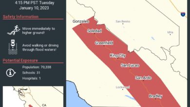
- Evacuation Orders: Evacuation orders are issued by local authorities based on the potential threat to life and property. These orders are communicated through various channels, including emergency alerts, local news, and social media. Understanding the difference between warnings and orders is vital; a warning indicates a potential hazard, while an order mandates immediate departure.
- Evacuation Routes: Common evacuation routes in Santa Clara County include Highway 85, Highway 101, and specific local roads. These routes are chosen based on traffic flow, access to neighboring jurisdictions, and potential hazards along the way. Residents should familiarize themselves with these routes before an emergency.
- Designated Assembly Points: Designated assembly points are locations where residents gather after evacuating. These points are strategically chosen to facilitate communication, account for evacuees, and ensure that residents are safely directed to appropriate resources.
Roles and Responsibilities of Agencies
Several agencies play critical roles in evacuation procedures. Clear communication and coordination are essential for a smooth and efficient response.
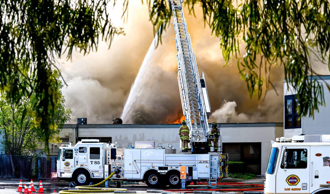
- Fire Departments: Fire departments are at the forefront of responding to wildfires and managing the immediate threat. They assess the situation, provide emergency assistance, and help manage evacuation routes.
- Police Departments: Police departments help maintain order and traffic control during evacuations. They direct traffic, monitor the flow of people and vehicles, and enforce any necessary restrictions.
- Emergency Management Agencies: Emergency management agencies coordinate the overall response. They work with various agencies to ensure resources are available, and communication channels are functional.
Comparison of Evacuation Procedures in Different Areas
The following table Artikels differences in evacuation procedures between specific areas of Santa Clara County. These procedures might differ based on geographic features, proximity to fire risk, and community resources.
| Area | Evacuation Routes | Assembly Points | Specific Considerations |
|---|---|---|---|
| Mountain View | Highway 85, Highway 101, local roads | Designated community centers, schools | High population density, potential traffic congestion |
| Cupertino | Highway 85, Highway 101, local roads | Community centers, open spaces | Proximity to tech industry, need for rapid response |
| Los Gatos | Highway 17, local roads | Designated parking lots, community centers | Rural/semi-rural areas, potential for slower response times |
Types of Warnings and Alerts
The following table details the different types of warnings and alerts used during evacuations. Recognizing these warnings is crucial for taking the necessary action.
| Alert Type | Description | Action Required |
|---|---|---|
| Evacuation Warning | Indicates a potential threat and the need to be prepared to evacuate. | Monitor local news, stay informed, gather essentials. |
| Evacuation Order | Mandates immediate departure from the area. | Evacuate immediately, follow designated routes. |
| Shelter-in-Place Order | Indicates that residents should stay indoors. | Stay indoors, close windows, and doors, monitor updates. |
Community Preparedness
Preparing for wildfires in Santa Clara County is a shared responsibility. Understanding the importance of community preparedness, and the proactive steps residents can take, is crucial in mitigating potential risks and ensuring safety during emergencies. This involves not just individual actions, but also the collaborative efforts of community organizations and resources.Community preparedness is about more than just knowing what to do; it’s about fostering a culture of resilience and preparedness within the community.
This requires individuals to understand their role in disaster response, and actively participate in community-wide efforts to enhance safety and preparedness. By being informed and proactive, residents can increase their ability to protect themselves and their families during emergencies.
Common Community Preparedness Measures
Residents of Santa Clara County often engage in various preparedness measures. These measures reflect a proactive approach to mitigating potential risks associated with wildfires. Common measures include creating evacuation plans, stocking emergency supplies, participating in community drills, and supporting local organizations involved in disaster preparedness. A combination of these actions enhances the community’s overall resilience to wildfire events.
Importance of Family Evacuation Plans
Developing a comprehensive family evacuation plan is essential. A well-defined plan Artikels escape routes, meeting points, and communication strategies in case of a wildfire. This structured approach ensures that families can respond effectively and efficiently during an evacuation, minimizing confusion and maximizing safety. Families should consider multiple evacuation routes, and practice the plan regularly. A critical component is establishing a designated meeting point outside the evacuation zone, and ensuring all members of the family are aware of the plan.
Importance of Emergency Supplies
Having emergency supplies on hand is vital. These supplies should be sufficient to meet basic needs for a period of several days. Essential items include water, non-perishable food, medications, first-aid supplies, flashlights, batteries, and a portable radio. Having a well-stocked emergency kit ensures that residents can maintain their safety and comfort during an evacuation. Regular checks and replenishment of supplies are crucial to ensure they remain in good condition and are adequate for the needs of the family.
Role of Community Organizations
Community organizations play a vital role in disaster preparedness. They often provide valuable resources, support, and training to residents. These organizations frequently conduct preparedness workshops, offer information sessions, and organize drills to familiarize residents with evacuation procedures and safety protocols. Many community groups also coordinate volunteer efforts during and after a disaster, assisting with resource distribution and support to affected residents.
Their involvement strengthens the community’s ability to respond to and recover from emergencies.
Resources for Evacuation Planning and Preparedness
| Resource | Description | Contact Information |
|---|---|---|
| Santa Clara County Office of Emergency Services | Provides information on evacuation procedures, preparedness guides, and community resources. | (Insert Contact Information Here) |
| American Red Cross | Offers preparedness workshops, emergency supplies, and support during and after disasters. | (Insert Contact Information Here) |
| Local Fire Departments | Provide fire safety education, community drills, and evacuation information specific to neighborhoods. | (Insert Contact Information Here) |
| Local Community Centers | Often host preparedness workshops and information sessions, and can be a designated meeting point during emergencies. | (Insert Contact Information Here) |
| Local Libraries | Offer resources on emergency preparedness, evacuation routes, and community information. | (Insert Contact Information Here) |
Wildfire Risk Factors in Santa Clara County

Santa Clara County, nestled in the foothills of the California Coast Ranges, faces a significant wildfire risk. Understanding the contributing factors is crucial for effective preparedness and community resilience. This blog post delves into the geographic, vegetation, and climate-related elements that heighten the threat of wildfires in the area.The complex interplay of these factors necessitates a proactive approach to wildfire prevention and response.
Getting ready for potential Santa Clara County wildfire evacuations is crucial. Thinking about the safety procedures and essentials is key. With the recent arrests related to the NBA All-Star weekend in Oakland, arrests enforcement nba all star weekend oakland and the heightened security presence, it’s important to double-check emergency plans. Ultimately, thorough preparation for Santa Clara County wildfire evacuations remains our top priority.
By recognizing the vulnerabilities and adapting strategies accordingly, the community can enhance its ability to mitigate the impact of future blazes.
Geographic Features Influencing Wildfire Spread
Santa Clara County’s topography significantly impacts wildfire behavior. The varied terrain, including hills, valleys, and canyons, creates pathways for fire to rapidly spread. Slopes and canyons often channel winds, increasing fire intensity and speed. The presence of dry, flammable vegetation exacerbates the situation, making the spread of wildfires more difficult to control. The proximity of the county to other fire-prone areas also amplifies the risk of fire spread, creating a cascading effect.
Vegetation Types and Density
The type and density of vegetation play a critical role in wildfire risk. The area’s mix of chaparral, grasslands, and woodlands creates a highly flammable landscape. Dense vegetation provides ample fuel for wildfires, making them more intense and harder to extinguish. Dry conditions, particularly during prolonged droughts, further exacerbate the problem by reducing the moisture content of plant material.
This combination of factors makes controlling a wildfire in Santa Clara County a significant challenge.
Impact of Climate Change on Wildfire Risk
Climate change is a major driver of increased wildfire risk in Santa Clara County. Warmer temperatures and drier conditions lead to longer fire seasons and increased drought frequency. Higher temperatures dry out vegetation, making it more susceptible to ignition and rapid spread. Increased frequency and intensity of extreme weather events, such as heat waves and strong winds, also contribute to wildfire risk.
These conditions make the existing risk significantly higher and require adaptation of mitigation strategies. For example, the 2020s have seen record-breaking heat waves, contributing to numerous wildfires across the state, including those in areas similar to Santa Clara County.
Past Wildfire Events in Santa Clara County
Santa Clara County has experienced several significant wildfires in recent history. These events highlight the importance of preparedness and response measures. These events have included, but are not limited to, specific instances where the impact on communities was substantial. For example, the [Insert specific past wildfire name here] wildfire in [Insert year] damaged homes and forced evacuations.
The scale of these events underscores the need for ongoing community engagement and proactive measures to minimize risks and maximize resilience in future events.
| Wildfire Name | Year | Impact |
|---|---|---|
| [Wildfire 1 Name] | [Year] | [Description of Impact, e.g., Forced evacuations, property damage] |
| [Wildfire 2 Name] | [Year] | [Description of Impact, e.g., Significant air quality issues, widespread damage] |
Evacuation Communication & Resources
Staying informed is crucial during wildfire evacuations. Knowing how to receive alerts and where to find reliable information can significantly impact safety and well-being. This section details the communication methods and resources available to residents of Santa Clara County to ensure a smooth and safe evacuation process.Accurate and timely communication is paramount during an emergency. Clear, consistent messages reduce confusion and help residents make informed decisions.
This includes knowing which methods to trust and how to access vital information quickly.
Methods of Evacuation Communication
Various methods are employed to disseminate evacuation information. Sirens are often used as a widespread alert, but their effectiveness can be limited by distance and potential interference. Public address systems and emergency broadcasts can also be used, but their reach depends on the specific area. Mobile alerts and text messages, which are increasingly common, allow for direct communication with individuals.
Social media plays a vital role in providing real-time updates.
Role of Social Media in Evacuation Information
Social media platforms have become critical tools for disseminating evacuation information. Official county accounts, local news outlets, and community groups frequently post updates, providing vital information about evacuation routes, shelters, and road closures. However, residents should verify information from unofficial sources with official channels to avoid misinformation.
Reliable Resources for Evacuation Information
Residents can obtain evacuation information from numerous reliable sources. Official county websites and social media accounts are critical resources. Local news outlets often provide up-to-date reports and announcements. Utilizing these resources alongside other official sources enhances the chances of receiving accurate information. Trusting only one source could lead to missing crucial updates.
Evacuation Resource Table
| Resource Type | Details |
|---|---|
| Websites | Santa Clara County Emergency Management website, local news websites |
| Mobile Apps | Emergency alert apps (e.g., Nixle, CodeRED) |
| Contact Numbers | Emergency Management Agency (EMA) contact number, local fire department numbers |
| Social Media | Official Santa Clara County and local news accounts |
Importance of Clear and Consistent Communication
Clear and consistent communication during an evacuation is essential. Ambiguous or contradictory messages can lead to confusion, panic, and potentially dangerous delays. This is particularly true during a wildfire emergency, where every second counts. A unified message, shared across multiple channels, is key to a smooth evacuation process. For example, if an official website and social media channels are posting different evacuation instructions, residents could be misled, and safety is jeopardized.
“Clear and concise communication is crucial for ensuring safety and order during an evacuation.”
Getting ready for potential Santa Clara County wildfire evacuations is crucial. Having a reliable communication plan is key, and that includes ensuring you have a backup method for video calls. This could involve using your Android phone as a webcam for video conferencing, a handy tool for staying connected during a crisis. Check out this guide on use android as webcam for more tips on setting up your phone as a virtual camera.
Even if you don’t anticipate needing it, having a plan in place for video communication will make a difference during a wildfire evacuation.
Evacuation Impacts & Mitigation
Evacuations, while crucial for safety during natural disasters like wildfires, bring about a range of challenges for individuals, families, and the wider community. Understanding these impacts and developing strategies for mitigation is vital for effective disaster preparedness and recovery. The potential economic, social, and psychological tolls on residents, as well as the disruptions to businesses and the local economy, are significant aspects of these events.
This section explores these impacts and the available support systems to lessen the negative effects.The psychological toll of evacuations can be profound. Uncertainty, fear, and the disruption of routines can lead to stress, anxiety, and even post-traumatic stress disorder (PTSD) in some individuals. Furthermore, the disruption of normal daily life, including school closures, work interruptions, and the separation from loved ones, can be emotionally challenging.
Mitigating these psychological impacts requires providing access to mental health resources and support networks.
Economic Impacts of Evacuations
Evacuations often disrupt businesses, leading to significant economic losses. Many businesses in Santa Clara County, particularly those in tourism, retail, and hospitality sectors, are likely to experience revenue decline or closure during evacuation periods. This economic disruption can affect local employment rates, small business owners, and the overall economy. Furthermore, the costs associated with temporary relocation, supplies, and other emergency needs can place a financial strain on individuals and families.
Social Impacts of Evacuations
Evacuations can also create significant social disruptions. The separation of families and friends, the loss of community connections, and the need to rely on unfamiliar resources can strain social bonds. This is particularly challenging for vulnerable populations, including seniors, individuals with disabilities, and families with young children. Developing community-based support systems and communication channels can help maintain social connections during and after an evacuation.
Mitigation Strategies for Evacuation Impacts
Effective mitigation strategies can lessen the negative impacts of evacuations. These strategies include pre-planning for financial assistance, establishing robust communication systems, and creating supportive networks within communities. Prioritizing access to essential resources like food, water, and shelter is also crucial.
Getting ready for potential Santa Clara County wildfire evacuations is top of mind, and with that comes stocking up on essentials. But amidst the prepping, it’s worth remembering to check for food safety too. Recent recalls of canned tuna sold at Trader Joe’s, Costco, and H-E-B, for instance, highlight the importance of verifying the safety of your food supplies, especially if you’re preparing for an emergency.
This is a good reminder to double-check expiration dates and recall notices before you head out to stock up on supplies for those wildfire evacuations. This recent canned tuna recall is a good example of why thorough preparation is key, even for things like food safety, when planning for any emergency. So, while focusing on the critical preparations for evacuations, let’s not forget about the food we’re packing.
- Financial Assistance Programs: Many organizations, including the county and federal governments, offer financial assistance to individuals and businesses impacted by evacuations. This can include aid for temporary housing, lost wages, and repair costs. Having knowledge of these programs before a disaster occurs can ease the recovery process.
- Communication and Information Sharing: Establishing clear communication channels, such as emergency alerts and social media platforms, allows residents to receive timely information about evacuation orders, shelters, and other essential resources. This can help mitigate confusion and stress.
- Community Support Networks: Creating and strengthening community support networks allows for mutual aid, sharing of resources, and emotional support during evacuations. These networks can be established through pre-disaster planning and community meetings. Having a network of trusted contacts before an event is essential.
Recovery Efforts Following Past Evacuations, Santa clara county wildfire evacuations preparations
Recovery efforts following past evacuations in Santa Clara County often involve a multi-faceted approach, encompassing financial aid, community support, and long-term rebuilding. The recovery process can be challenging, requiring sustained efforts from various stakeholders. A critical component of recovery is the rebuilding of trust and normalcy within the affected communities. Understanding the specific needs of each community is essential for effective recovery.
Support Systems During and After Evacuations
Several support systems are available to residents during and after evacuations. These include temporary shelters, emergency food and water supplies, and mental health services. Moreover, community organizations and volunteer groups often play a vital role in providing support and assistance to affected individuals and families. Access to these support systems can significantly ease the transition back to normalcy.
- Temporary Shelters: Local authorities and organizations set up temporary shelters to provide safe and secure housing for displaced residents. These shelters often provide basic necessities like food, water, and medical assistance.
- Emergency Services: Emergency services, including medical personnel, firefighters, and law enforcement, provide critical support during and after evacuations. They work tirelessly to ensure the safety and well-being of the community.
- Community Organizations: Community organizations and volunteer groups provide essential support, including food distribution, emotional support, and assistance with finding temporary housing.
Technology in Evacuation Planning: Santa Clara County Wildfire Evacuations Preparations
Technology is rapidly transforming how we prepare for and respond to natural disasters like wildfires. Leveraging digital tools can streamline communication, improve evacuation route planning, and enhance overall community safety. This allows for faster response times, better resource allocation, and ultimately, more lives saved.Utilizing technology in evacuation planning goes beyond simply having a website. It involves integrating data-driven insights and sophisticated mapping to make critical decisions during a crisis.
This proactive approach is vital for minimizing the impacts of wildfires and ensuring a swift and coordinated evacuation process.
Mapping Tools for Evacuation Route Planning
Accurate and up-to-date maps are crucial for identifying evacuation routes, considering terrain, and assessing potential road closures. Digital mapping tools allow for real-time updates on traffic conditions, road closures, and potential hazards. This enables emergency responders and citizens to make informed decisions regarding the most efficient and safest routes.Advanced mapping platforms can incorporate various data layers, such as topographical maps, infrastructure information, and historical wildfire data.
This allows for the creation of dynamic evacuation plans that can be adapted based on changing conditions. For example, a map could highlight areas with high wildfire risk and show alternative routes in case of blocked primary evacuation paths.
Mobile Apps for Evacuation Alerts
Mobile applications provide a critical channel for delivering timely and relevant evacuation alerts. These apps can be customized to send notifications based on location, allowing individuals to receive alerts specific to their area. This ensures that residents receive evacuation orders promptly, minimizing confusion and potential delays. Furthermore, apps can provide real-time updates on the progress of the fire and any changes to evacuation zones.
GIS in Analyzing Wildfire Risk
Geographic Information Systems (GIS) play a significant role in analyzing wildfire risk. GIS combines spatial data with attributes to create detailed maps of wildfire susceptibility. By incorporating factors like vegetation density, topography, and historical fire patterns, GIS models can identify high-risk areas and provide insights into potential fire spread. This predictive capability allows for proactive measures to mitigate wildfire risk.For instance, a GIS analysis could identify areas with dense vegetation and steep slopes, determining the potential for rapid fire spread.
This allows authorities to focus resources on preventative measures and early intervention strategies.
Data Visualization for Communicating Wildfire Risk
Data visualization techniques are essential for effectively communicating wildfire risk to the public. Visual representations of risk levels, such as heat maps or shaded areas, can make complex data accessible and understandable to a broader audience. This allows for clear communication of potential dangers and the importance of preparedness. These visuals can also be integrated into interactive websites and mobile apps, empowering individuals to assess their own risk and take appropriate actions.For example, a heat map overlaid on a city map could highlight areas at high risk of wildfire, guiding residents to areas with lower risk or alternative evacuation routes.
Such visualizations enhance understanding and prompt proactive measures to prevent harm.
Final Thoughts
In conclusion, thorough preparation is paramount during wildfire evacuation scenarios. By understanding the specific risks, procedures, and resources available in Santa Clara County, residents can significantly enhance their safety and preparedness. This guide provides a detailed framework to help communities face such challenges effectively and mitigate potential negative impacts. Ultimately, proactive planning and community engagement are key to ensuring safety and resilience in the face of wildfire threats.