
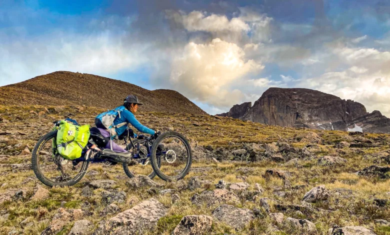
In 2017, Quinn Brett, a seasoned National Park Service climbing ranger, experienced a life-altering accident while ascending the iconic El Capitan in Yosemite National Park. A 120-foot fall resulted in a spinal cord injury that left her paralyzed from the waist down, effectively ending her career as a high-altitude climber. For Brett, the recovery process was not merely physical; it was a profound confrontation with the limitations of the American landscape. Transitioning from the vertical world of rock faces to the reality of life in a wheelchair, she encountered a systemic exclusion from the very public lands she had once managed. This personal pivot served as the catalyst for a broader movement, culminating in the Bureau of Land Management’s (BLM) launch of a new, highly detailed interactive accessibility map on October 13, 2026. This digital tool, developed with the expertise of Brett’s consulting firm, Dovetail Trail Consulting, represents a significant shift in how federal agencies perceive, manage, and communicate accessibility for the nearly 30 million Americans who live with mobility-related disabilities.
A Chronology of Exclusion and Advocacy
The challenge of navigating public lands with a mobility disability is not a new phenomenon, but it has gained significant institutional momentum in the post-pandemic era. Before the current wave of federal initiatives, accessibility information for hikers, campers, and outdoor enthusiasts with disabilities was notoriously fragmented.
Following her accident, Brett spent years navigating the landscape of federal land management, realizing that the absence of granular data was a more significant barrier than the terrain itself. For someone who uses a wheelchair, "accessibility" is not a binary state of open or closed. It is a nuanced spectrum dictated by slope percentage, surface composition, gate widths, and the availability of accessible infrastructure like vault toilets.
In the years following her 2017 injury, Brett transitioned from an NPS employee to a consultant. By 2024, as federal agencies began responding to renewed pressure under the Americans with Disabilities Act (ADA) and subsequent executive orders regarding equity in federal recreation, the BLM sought to modernize its digital footprint. The collaborative project that led to the October 2026 map launch was a three-year intensive effort, involving the collection of crowdsourced data, site audits, and the integration of GIS mapping technology to provide users with a "pre-trip" experience that mitigates the risk of encountering unexpected, impassable barriers.
Data-Driven Landscapes and the Need for Inclusion
The impetus for this project is rooted in demographic reality. According to data from the Centers for Disease Control and Prevention (CDC), roughly one in ten American adults reports significant mobility limitations. As mobility device technology evolves—ranging from off-road handcycles to sophisticated, terrain-capable power wheelchairs—the demand for diverse outdoor experiences has surged.
"For a long time, we only had one pair of shoes to pick," Brett explained in an interview regarding the initiative. "Now, with the evolution of adaptive equipment, we have an entire closet of options. The goal is to ensure that those options can be used in a variety of environments, not just on a singular, one-mile paved loop in a high-traffic tourist zone."

The BLM’s new interactive map is designed to be a living, dynamic resource. It currently features 50 verified, high-quality recreation opportunities. A key example is the McCoy Flats trail system in Utah, where the map provides prospective visitors with precise information regarding parking surface density—critical for preventing wheels from sinking—as well as the specific dimensions and layouts of picnic areas and sanitation facilities.
Furthermore, the map acts as a strategic planning tool for the agency, identifying 74 additional sites where infrastructure improvements are either funded or proposed. By categorizing sites like the Blue Valley Ranch Trail in Colorado as "in-progress" and the Glade Run Adaptive Trail in New Mexico as "funding-pending," the BLM is providing transparency that allows stakeholders, advocacy groups, and private donors to see exactly where resources are most needed to complete the accessibility puzzle.
The Role of Citizen Science in Public Land Management
One of the most innovative aspects of the BLM’s strategy is the integration of crowdsourced reporting. The infrastructure of America’s public lands is vast, spanning millions of acres, and government agencies face significant budgetary and staffing constraints when it comes to surveying every mile of trail. By empowering visitors to document trail conditions through a user-friendly interface—uploading photos of trailheads, gate widths, and surface types—the BLM is effectively scaling its data collection efforts.
Julia Ray, Chief Operating Officer of Move United, an organization that has been instrumental in partnering with the National Park Service and the BLM to standardize these assessments, emphasizes the importance of this ongoing process. "Trails are dynamic, living environments," Ray stated. "They are subject to seasonal erosion, flooding, and weather-related damage. A trail that was accessible in the spring might be impassable by late autumn. Keeping this information current requires a collective effort."
Move United’s involvement includes not only field assessments of over 17 miles of trails in major parks like Mount Rainier and the Grand Canyon but also the development of educational curricula. By training local land managers in federal accessibility standards, the organization aims to bridge the gap between policy and practice, ensuring that accessibility is considered at the design phase rather than as an afterthought.
Implications for the Future of Federal Recreation
The shift toward universal design and accessible infrastructure has broader implications for the national park and public land system. Beyond the obvious benefit to individuals with mobility disabilities, these improvements often result in better experiences for aging populations, parents with strollers, and casual hikers who benefit from better-maintained trail grades and surfaces.
However, the transition is not without challenges. Critics and some land managers have expressed concerns about the tension between maintaining the "wild" character of remote lands and the infrastructure requirements for accessibility. Brett, however, argues that the two are not mutually exclusive. Her work with Dovetail Trail Consulting centers on the philosophy that true accessibility is about information and intention.

"You don’t have to engage in a massive construction project to make a place more welcoming," Brett says. "Often, it is as simple as taking a photograph of a gate and posting it online. If someone knows that a gate is 30 inches wide, they can make their own decision about whether their equipment will fit. If we don’t provide that information, we are effectively telling them that they don’t belong."
The financial aspect remains a significant hurdle. While the EXPLORE Act and other legislative vehicles have brought increased attention to outdoor access, funding remains localized and competitive. The inclusion of "funding-pending" projects on the BLM map is a calculated move to invite private-public partnerships, allowing local communities and organizations to champion specific trails that are ready for improvement.
A New Standard for Equity
The launch of the BLM map is a landmark in the evolution of federal land management. By prioritizing the experiences of those with mobility challenges, the agency is acknowledging that the "great outdoors" should not be an exclusive domain for the able-bodied.
The success of this initiative will be measured not just by the number of miles mapped, but by the change in user demographics on the trail. As information becomes more transparent and infrastructure becomes more intentional, the hope is that public lands will begin to reflect the diversity of the American population. For Quinn Brett, the mission is deeply personal. She continues to advocate for the right to push her own limits, acknowledging that her desire to reach mountain summits remains as strong as ever.
"I still want to be playing and going to the top of mountains and doing wild and crazy things," she says. "But I also need the information to decide what experience I want to have. When you provide that, you aren’t just making a trail accessible; you are restoring the agency of the visitor."
As the BLM and other agencies look to the future, the focus will likely remain on integrating these digital tools with on-the-ground management. The goal is a seamless, user-centric experience where the barrier to entry is lowered, and the focus remains on what matters most: the connection between the individual and the vast, untamed beauty of the American landscape. With the current momentum, the federal government appears to be moving toward a more inclusive future, one where the "wild" is defined not by how hard it is to access, but by how well it is understood and shared by all.