Discovering Saba: The Caribbean’s Unspoiled Queen Through Conservation, Culture, and Community

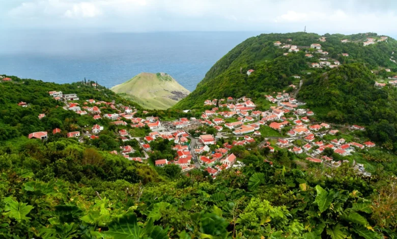
Nestled in the northeastern Caribbean, the island of Saba stands as a rare anomaly in a region heavily shaped by mass tourism, sprawling mega-resorts, and commercialized beachfronts. Often referred to by locals and seasoned travelers as the “Unspoiled Queen of the Caribbean,” this volcanic island fiercely maintains its ecological and cultural identity through deliberate, limited development. Approximately one-third of Saba’s terrestrial and marine territory is strictly protected under a comprehensive national park system. This network comprises the Mount Scenery National Park, the Saba National Marine Park, and the expansive Saba Bank National Park. By prioritizing sustainable tourism and community-led preservation, Saba offers an immersive, low-impact travel experience that contrasts sharply with neighboring Caribbean destinations.
Main Facts and Geographical Overview
Saba is the smallest special municipality of the Netherlands, encompassing a mere five square miles of dramatic volcanic terrain. Rising steeply from the azure waters of the Caribbean Sea, the island lacks traditional sandy beaches, a factor that has historically deterred high-volume cruise tourism. Instead, visitors encounter towering cliffs, dense cloud forests, and a meticulously preserved architectural heritage.
The island’s infrastructure is equally unique. Arriving flights land at the Juancho E. Yrausquin Airport (SAB), widely recognized as possessing one of the shortest commercial runways in the world, perched dramatically on a shelf of rock flanked by cliffs and the sea. From the airstrip, travelers navigate “The Road,” the island’s sole paved route, which connects the airport to villages such as Windwardside, The Bottom, and Hell’s Gate. Characterized by hairpin turns and steep inclines, the road is a testament to human ingenuity and local perseverance.
A Historical Chronology of Infrastructure and Survival
The realization of Saba’s infrastructure and cultural resilience is deeply rooted in its history. For generations, the island’s economy relied heavily on seafaring, with a majority of Saban men working as sailors and ship captains abroad. This left women to manage the domestic economy and sustain local livelihoods.
In the 1870s, Saban women introduced drawn threadwork, commonly known as “Saba lace,” to supplement household incomes. The craft quickly evolved into a lucrative mail-order enterprise, shipping intricate textiles to North America, Europe, and the wider Caribbean. Until the mid-20th century, this trade served as a primary economic pillar, earning the island the secondary moniker “The Island of Lace.” Master artisans worked by the light of kerosene lamps well into the night, passing the technique down through generations. Today, elder artisans known as the "Lace Ladies" continue to offer free workshops to local youth, ensuring the survival of this rare cultural touchstone alongside revival efforts for traditional palm-weaving and plaiting arts.
The island’s transportation history is equally storied. In the early 20th century, foreign engineers surveyed Saba’s vertical topography and declared it impossible to construct a motor road due to the prohibitive gradient. Undeterred, local residents under the leadership of Josephus Lambert Hassell took education into their own hands, studying civil engineering via correspondence courses. Using hand tools, local laborers constructed The Road entirely by hand, completing the monumental project in 1963. This infrastructure connected the island’s isolated settlements and laid the groundwork for modern, controlled tourism.
Conservation Framework and Environmental Stewardship
Saba’s environmental policy is enforced through the Saba Conservation Foundation (SCF), established to protect the island’s terrestrial and marine ecosystems. Tom Brokke, a Senior National Park Officer with the SCF, emphasizes that the island’s current state is the result of intentional, long-term planning.
"What makes Saba special is its natural beauty, the dramatic landscapes, and the fact that development has remained relatively small-scale and in character with the island," Brokke notes. "The small boutique hotels and locally owned businesses actually add to that identity rather than taking away from it."
The marine environment has experienced stringent protections since the establishment of the Saba National Marine Park in 1987. Spanning the entire coastal perimeter from the high-water mark down to a depth of 200 feet, the marine park safeguards coral reefs, sea grass beds, and pelagic habitats. Strict anchoring and fishing regulations have maintained exceptional water clarity, allowing snorkelers and divers to observe thriving populations of sea turtles, rays, reef sharks, and migratory cetaceans.
On land, the terrestrial parks protect diverse microclimates. Mount Scenery, the highest point in the Kingdom of the Netherlands at over 2,900 feet, anchors a cloud forest environment. As hikers ascend the stone steps of trails such as Mas’Cohones and the main peak trail, dramatic altitude shifts produce distinct ecological zones, transitioning from dry scrublands to humid rainforests rich in endemic flora and fauna.
Socioeconomic Implications of Sustainable Tourism
Saba’s conscious rejection of mass-market tourism carries significant economic and social implications. By capping hotel capacity—currently limited to a handful of boutique properties and family-run guesthouses such as Juliana’s Hotel—the island avoids the environmental degradation and economic leakage often associated with large-scale resort development.
Property aesthetics are strictly regulated by a municipal building code, requiring traditional Saban architecture: stark white walls, contrasting red shingled roofs, green-and-white or red-and-white shutters, and intricate gingerbread trim. This architectural continuity preserves the historical aesthetic of settlements like Windwardside while supporting local employment through construction and maintenance aligned with heritage standards.
Furthermore, the local culinary scene heavily integrates sustainability. Restaurants across the island, including Tropics Cafe, Brigadoon, and The Hideaway, emphasize locally sourced ingredients, fresh catches from the protected Saba Bank, and farm-to-table practices. This localized economic loop ensures that tourism revenue directly benefits residents, preserving the community-centric fabric that defines daily life on the island.
Logistical Access and Practical Visitor Information
Reaching Saba requires careful itinerary planning, as there are no direct commercial flights from North America or Europe. Travelers typically fly into Princess Juliana International Airport (SXM) in neighboring St. Maarten. From there, regional carrier Winair operates multiple daily flights to Saba’s Juancho E. Yrausquin Airport, lasting approximately 15 minutes. Alternatively, the Makana Ferry provides maritime transport between St. Maarten and Fort Bay Harbor, though sea conditions can vary significantly.
Due to the island’s steep topography and rugged terrain, visitors are advised to wear appropriate footwear, such as hiking boots, rather than standard casual wear. With limited large-scale commercial imports and a deliberate focus on low-density visitation, Saba remains a distinct model for sustainable island management, demonstrating that ecological preservation and community heritage can successfully thrive in the modern tourism landscape.
Related posts: