Defying Gravity and Danger: Greek Drivers Continue to Cross Collapsed Bridge in Larissa Following Storm Daniel

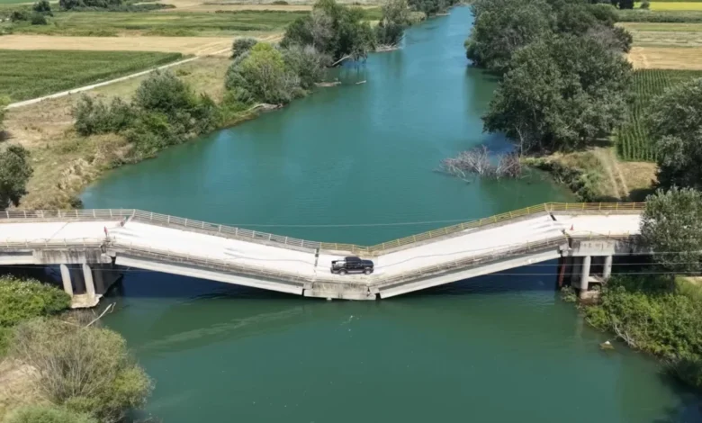
In the regional unit of Larissa, located within the heart of Greece’s agricultural center, a scene of profound structural instability has become a daily reality for local commuters. Despite a bridge being visibly fractured and partially submerged in the river below, motorists continue to traverse the compromised structure, sparking significant concerns regarding public safety and the pace of infrastructure recovery in the wake of catastrophic weather events. The bridge, which serves as a vital link between two municipalities split by a river, suffered devastating structural failure during the onset of Storm Daniel, yet it remains a utilized—albeit hazardous—conduit for those unwilling or unable to navigate lengthy detours.
The Current State of the Larissa Bridge
Visual evidence, including recent drone reconnaissance, reveals a structure that defies conventional engineering logic by remaining standing. The bridge has suffered catastrophic failure in at least four distinct sections, resulting in a pronounced "V-shaped" dip where the center of the span now makes direct contact with the water’s surface. This sagging "belly" of the bridge is subjected to constant hydraulic pressure from the river current, further undermining what little structural integrity remains.
Eyewitness reports and video footage show a variety of vehicles, ranging from passenger cars to heavy-duty pickup trucks, navigating the steep incline and decline created by the bridge’s collapse. Drivers are seen slowing to a crawl as they reach the fracture points, gingerly moving over the broken asphalt and exposed rebar. The spectacle has drawn comparisons to extreme off-road trials, but for the residents of Larissa, it is a desperate measure born of necessity.
Background: The Legacy of Storm Daniel
To understand the current state of infrastructure in central Greece, one must look back at the unprecedented meteorological event known as Storm Daniel. Striking the Mediterranean in September 2023, the storm is recorded as the deadliest and costliest Mediterranean-like cyclone in history. In parts of the Thessaly region, which includes Larissa, the storm dropped more than 800 millimeters of rain in a 24-hour period—an amount equivalent to a full year’s worth of precipitation in many European capitals.
The resulting floods did not merely submerge the landscape; they fundamentally altered the geography of the region. Thousands of hectares of prime farmland were turned into inland seas, and the force of the rushing water decimated the region’s transportation network. Bridges that had stood for decades were swept away or, as in the case of the Larissa crossing, left in a state of partial collapse. While the immediate humanitarian crisis was addressed in the months following the storm, the long-term reconstruction of secondary and tertiary infrastructure has lagged significantly behind, leaving communities isolated and forcing the "bravery or stupidity" currently observed at the river crossing.
A Chronology of Decay and Inaction
The timeline of the bridge’s deterioration highlights a growing gap between disaster occurrence and infrastructural resolution.
- September 2023: Storm Daniel strikes central Greece. Record flooding causes the river levels in Larissa to rise beyond design limits, leading to the initial structural failure of the bridge’s piers.
- Late 2023: Initial assessments by local municipalities identify the bridge as "unsafe for use." Minor barriers are reportedly erected, but they are frequently moved or bypassed by residents.
- 2024: As the regional economy attempts to recover, the lack of a functional crossing becomes a primary grievance for local farmers and businesses. The detour required to bypass the bridge adds significant time and fuel costs to daily operations.
- Present Day: The bridge remains in its collapsed state. Drone footage confirms that despite the visible danger, the crossing has become a regular route for locals. Reports emerge of tourists nearly driving into the river due to a lack of clear signage and outdated digital maps.
The Mechanics of Structural Failure
Structural engineers warn that the continued use of the bridge is a "ticking time bomb." When a bridge sags to the point of touching the water, it is no longer just supporting the weight of the vehicles crossing it; it is also acting as a dam. The water pressure against the side of the submerged span creates lateral forces that the bridge was never designed to withstand.
Furthermore, the four distinct breaks in the deck indicate that the internal steel reinforcements have likely reached their yield point. Every vehicle that crosses the bridge introduces dynamic loads—vibrations and weight shifts—that cause microscopic expansions in the existing cracks. Engineering experts suggest that the "final straw" could be anything from a slightly heavier-than-usual truck to a minor increase in the river’s flow rate after a heavy rain.
The Economic and Psychological Drivers of Risk
The decision to cross a collapsing bridge is rarely a matter of thrill-seeking; rather, it is an indicator of economic pressure. The Thessaly region is the "breadbasket of Greece," responsible for a significant portion of the nation’s agricultural output. For a farmer operating on thin margins, a 30-to-40-minute detour to reach a field or a processing plant on the other side of the river represents a substantial loss of time and money.
High fuel prices in Greece, which consistently rank among the highest in the European Union, further incentivize the use of the shorter, albeit dangerous, route. This has led to a "normalization of risk" among the local population. When one driver successfully crosses the bridge, it provides a false sense of security for the next, creating a cycle of dangerous behavior that persists until a tragedy occurs.
Digital Hazards and the Tourist Trap
While locals may be aware of the bridge’s condition, travelers and tourists are at much higher risk. One of the most significant issues identified by safety advocates is the role of digital navigation tools. Google Maps and other GPS services still list the bridge as an active, intact roadway. Street view data, which has not been updated since the storm, shows a pristine concrete structure.
Drivers following GPS instructions often do not realize the bridge is out until they are already committed to the approach. Because the bridge appears flat from a distance, the "dip" only becomes visible when a vehicle is within a few dozen meters of the fracture. This has reportedly led to numerous incidents of emergency braking and precarious reversing maneuvers on narrow access roads. The lack of standardized, high-visibility warning signage several kilometers ahead of the bridge exacerbates this problem, turning a local infrastructure failure into a potential trap for international travelers.
Official Responses and the Path to Reconstruction
The local government in Larissa and the regional authorities of Thessaly have faced mounting criticism for the perceived delay in repairs. In statements regarding the general state of the region, officials have pointed to the sheer scale of the damage caused by Storm Daniel as the primary reason for the slow progress. The cost of rebuilding the region’s infrastructure is estimated in the billions of euros, necessitating significant funding from the central Greek government and the European Union’s Solidarity Fund.
However, the specific failure to barricade the Larissa bridge effectively remains a point of contention. Local residents have expressed concern that the government is waiting for a total collapse or a fatal accident before taking definitive action. "We have sent letters, we have made calls, but the bridge remains as it is," one local resident reported. "They tell us there is no budget yet for a new bridge, but surely there is a budget for a few concrete blocks to stop people from dying."
Broader Implications for Infrastructure Resilience
The situation in Larissa serves as a case study for the challenges facing Mediterranean nations in an era of climate volatility. As extreme weather events like Storm Daniel become more frequent and severe, the "resilience gap"—the difference between the pace of environmental destruction and the pace of bureaucratic reconstruction—is widening.
The Larissa bridge is not an isolated incident but a symptom of a larger struggle to maintain aging infrastructure against modern environmental pressures. It highlights the need for:
- Rapid Response Barricading: Ensuring that failed structures are physically impassable within hours of a disaster.
- Dynamic Mapping Partnerships: Better communication between local governments and tech companies like Google and Apple to update road statuses in real-time following disasters.
- Climate-Adaptive Engineering: Moving beyond "repairing" old designs and instead "rebuilding" with higher piers and reinforced foundations that can withstand future "100-year storms" that now occur with greater frequency.
Conclusion: A Precarious Future
As it stands, the bridge in Larissa remains a monument to both the destructive power of nature and the desperate resilience of the human spirit. While the sight of a truck crossing a broken, water-touching span may make for a compelling visual, it represents a failure of public safety systems.
Until the regional government can secure the necessary funding and technical expertise to either demolish the remains or begin a full reconstruction, the bridge will continue to sag under the weight of every passing vehicle. The question remains not if the bridge will finally give way, but who will be on it when it does. For the residents of Larissa, the hope is that the wheels of bureaucracy will eventually turn faster than the current of the river below, providing a safe crossing before the "final straw" arrives.